Peta Digital Dusun Pagersari, Mranggen, Srumbung, Magelang Berbasis Aplikasi CarryMap
Digital Map of Pagersari Hamlet, Mranggen, Srumbung, Magelang Based on CarryMap Application
DOI:
https://doi.org/10.33084/pengabdianmu.v6i3.2079Keywords:
CarryMAp, GIS, Digital map, Pagersari HamletAbstract
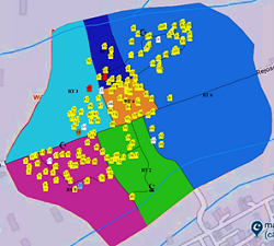
Pagersari is a hamlet located in Srumbung Magelang District, which is planned to be developed into a tourist village. To access the hamlet, a map showing the location and informative information is needed so that tourists can easily reach the location. The hamlet must have an information system containing partial administrative data. The problem often occurs the lack of administrative processing that provides complete, accurate, and easy-to-update data. This service aims to update the hamlet information system by mapping the hamlet, which contains information on population data and other attributes according to the needs based on Geographical Information Systems (GIS) and assisted by using ArcGIS then exported to CarryMap software. The implementation method is collecting population data from family cards, taking coordinate points, and inputting the ARCGIS software. The results obtained are that the public can find out in detail the location of the residents' houses and the population data available in the form of an online map. Therefore, the community can more easily access or update the hamlet population data through the operator. The community can also list the business opportunities they have. With an accurate digital map, it can make it easier for the outside community to find the location of tourist attractions that the village will plan as a tourism village by the potential of each hamlet.
Downloads
References
Bahtiar, H., Wijaya, L.K. 2020. Mobile Based Geographic Information System for mapping and data collection Towards 4.0 Industry. Journal of Physics: Conference Series. 1539:012012. https://doi.org/10.1088/1742-6596/1539/1/012012
Charter, D., Agtrisari, I. 2003. Desain Dan Aplikasi GIS Geographics Information System. Jakarta: Elex Media Komputindo.
Harseno, E., Tampubolon, V.I.R. 2007. Aplikasi Sistem Informasi Geografis Dalam Pemetaan Batas Administrasi, Tanah, Geologi, Penggunaan Lahan, Lereng, Daerah Istimewa Yogyakarta Dan Daerah Aliran Sungai Di Jawa Tengah Menggunakan Software. Majalah Ilmiah UKRIM. 12(1):63-80.
Ilhami, M.F., Nugraha, A.L., Firdaus, H.S. 2017. Visualisasi Peta Fasilitas Penunjang Wisata Religi Kabupaten Demak Menggunakan Aplikasi Carrymap (Studi Kasus Masjid Agung Demak Dan Makam Kadilangu). Jurnal Geodesi Undip. 6(4):219-225.
Irwansyah, E. 2013. Sistem Informasi Geografis: Prinsip Dasar Dan Pengembangan Aplikasi. Digibook Yogyakarta.
Justian, W., Taufik, M. 2019. Potency Analysis of the Batik MSMES Industrial in Surabaya Using Geographic Information System. IPTEK Journal of Proceedings Series. 2:6-10. https://dx.doi.org/10.12962/j23546026.y2019i2.5297
Longley, P.A., Goodchild, M.F., Maguire, D.J., Rhind, D.W. 2005. Geographical Information Systems: Principles, Techniques, Management and Applications, 2nd Edition, Abridged. New York: John Wiley & Sons.
Maesaroh, S., Erliyani, I., Ningsih, Y.F. 2020. Aplikasi Pengolahan Data Kependudukan Industri 4.0 Berbasis Web. Journal Cerita: Creative Education of Research in Information Technology and Artificial Informatics. 6(1):95-105. https://doi.org/10.33050/cerita.v6i1.892
Moldovan, M.O., Dirja, M., Gliga, I.D., Voevod, M. 2019. Making a Digital Database Regarding Land Antierosion Organization Works and Its Dissemination Through the Carry Map Extension. Land Reclamation, Earth Observation & Surveying, Environmental Engineering. 8:142-147.
Sai, S.S., Purwanro, H., Batara, Y.D., manek, M.P.M. 2019. Mobile SIG Dalam Visualisasi Peta Rencana Detail Tata Ruang Kota Dengan Pemotretan Udara Tanpa Awak. Jurnal Poros Teknik. 11(1):23-30. https://doi.org/10.31961/porosteknik.v11i1.800
Syafriani, D. 2012. Pembuatan Sistem Informasi Geografis Pelayanan Umum Di Kecamatan Nanggalo. Jurnal Momentum. 13(2):1-11.
Widodo, T.H., Nurhayati, O.D., Windasari, I.P. 2016. Pembuatan Aplikasi Sensus Penduduk Untuk Desa Wulunggunung. Jurnal teknologi dan Sistem Komputer. 4(1):9-16. https://doi.org/10.14710/jtsiskom.4.1.2016.9-16
Downloads
Published
How to Cite
Issue
Section
License
Authors who publish with this journal agree to the following terms:
- Any article on the copyright is retained by the author(s).
- Author grant the journal, right of first publication with the work simultaneously licensed under a Creative Commons Attribution License that allows others to share work with acknowledgment of the work authors and initial publications in this journal.
- Authors are able to enter into a separate, additional contractual arrangements for non-exclusive distribution of published articles of work (eg, post-institutional repository) or publish it in a book, with acknowledgment of its initial publication in this journal.
- Authors are permitted and encouraged to post their work online (e.g., in institutional repositories or on their websites) prior to and during the submission process, as can lead to productive exchanges, as well as earlier and greater citation of published work.
- The article and any associated published material is distributed under the Creative Commons Attribution-ShareAlike 4.0 International License