Focus Group Discussion Pembuatan Peta Batas Wilayah Padukuhan di Kalurahan Kebonharjo, Kapanewon Samigaluh, Kabupaten Kulon Progo Focus Group Discussion on Hamlet Boundary Mapping of Kebonharjo Village, Samigaluh District, Kulon Progo Regency
Article Sidebar
Main Article Content
Abstract
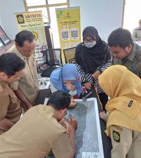
Geospatial information has expanded widely, including development and regional aspects. Kebonharjo sub-district, which is in the Kapanewon Girimulyo administrative area, Kulon Progo Regency, is committed to participating in regional development by trying to optimize its various potentials. However, the database and profile of potentials (and problems) are still limited, need better documented, and are still limited to tabular data. The database and profile will have added value if presented with a spatial approach like a map. Community service programs were carried out to make a map as a basis for developing spatial data and profiles. In the preparation step, the agendas include discussion with the village official to scope the activities and products, downloading satellite image data as a basis for mapping, and collecting maps for initial reference for area boundaries. Next, the technical activities for making the map were started by carrying out the Focus Group Discussion with village officials and community representatives from all of the hamlets to obtain agreement on the boundaries of the hamlet and Rukun Tetangga (RT) areas. The results of the Focus Group Discussion were digitized and processed in the laboratory to obtain map products and an overview of public understanding regarding mapping. The output achieved from the community service was the Padukuhan and Rukun Tetangga Area Boundary Map products, both in printed and soft file versions.
Downloads
Article Details

This work is licensed under a Creative Commons Attribution-ShareAlike 4.0 International License.
Authors who publish with this journal agree to the following terms:
- Any article on the copyright is retained by the author(s).
- Author grant the journal, right of first publication with the work simultaneously licensed under a Creative Commons Attribution License that allows others to share work with acknowledgment of the work authors and initial publications in this journal.
- Authors are able to enter into a separate, additional contractual arrangements for non-exclusive distribution of published articles of work (eg, post-institutional repository) or publish it in a book, with acknowledgment of its initial publication in this journal.
- Authors are permitted and encouraged to post their work online (e.g., in institutional repositories or on their websites) prior to and during the submission process, as can lead to productive exchanges, as well as earlier and greater citation of published work.
- The article and any associated published material is distributed under the Creative Commons Attribution-ShareAlike 4.0 International License
References
Boissière M, Duchelle AE, Atmadja S dan Simonet G. 2019. Panduan teknis pelaksanaan pemetaan desa partisipatif. Bogor, Indonesia: CIFOR. 19 pp. https://doi.org/10.17528/cifor/007338
Fardani, I. 2018. Participatory Mapping Solutionfor Village Potential and Boundary. PROCEEDINGThe 9th International Conference of Rural Research and Planning Group.
Hettiarachchi, C.J.et.al. 2022. Participatory GIS-Based Approach for the Demarcation of Village Boundaries and Their Utility: A Case Study of the Eastern Boundary of Wilpattu National Park, Sri Lanka. International Journal of Geo-Information. 2022, 11, 17. https://doi.org/10.3390/ijgi11010017
Marfai, M.A. 2016. Pentingnya Peta Desa dalam Percepatan Pembangunan Desa. Materi dipresentasikan pada Seminar Nasional Peta Desa untuk Percepatan Pembangunan Desa dan Kawasan Perdesaan. Februari 24. Yogyakarta
Nasrullah, N. et.al. 2023. The Compilation of Village Map in Community Service Activities in Blumbungan Village, Larangan District, Pamekasan Regency. AL-RIDHA: Jurnal Pengabdian kepada Masyarakat. 1(1) https://doi.org/10.58223/al-ridha.v1i1.52
Nurdin, N. et.al. 2021. Spatial Technology Based Participatory Digital Database for Village Potentials. The 6th International Conference on Tropical and Coastal Region Eco-Development. http://dx.doi.org/10.1088/1755-1315/750/1/012053
Pemerintah Indonesia. 2011. Undang Undang Nomor 4 Tahun 2011 Tentang Informasi Geospasial. Lembaran Negara Republik Indonesia Tahun 2011 Nomor 49. Kementerian Sekretariat Negara RI. Jakarta
Singh, P.K and Chudasama, H. 2023. Geo-Information-enabled Village Level Micro-Planning for Enhancing Common Good. Technological Forecasting and Social Change. 189, 122336. https://doi.org/10.1016/j.techfore.2023.122336
Adeswastono, H ., Islah, M ., & Saputra . (2022). Penyusunan Peta Desa Dalam Rangka Pengembangan Desa diDesa Pulau Terap Kecamatan Kuok . 1(1)
Kaehe, D ., Ruru, M , D .,& Rompas , Y , W Partisipasi Masyarakat Dalam Perencanaan Pembangunan Dikampung Pintareng Kecamatan Tabukan Selatan Tenggara